
Click for Printable Version Call Toll Free: 866-448-3070 (35.694946, -83.680458)
Do yourself a favor, and follow these directions, NOT those provided by Map Quest or some GPS Units unless you are a glutton for punishment! This is a trust me factor… The directions on our website are the most accurate coming from any direction. Please print them off. Coming from points west or south they often send you all the way to Knoxville instead of getting you off at the closest exit. Coming from the north they often send you through Pigeon Forge traffic instead of coming via Maryville which can add 2 hours or more onto your time. If you would rather bond with your spouse sitting in traffic using your new GPS, okay. I’ll tell you what the sunset looked like when you do arrive. 🙂 Confusing? Call 866-448-3070.
From Nashville on I-40 EB:
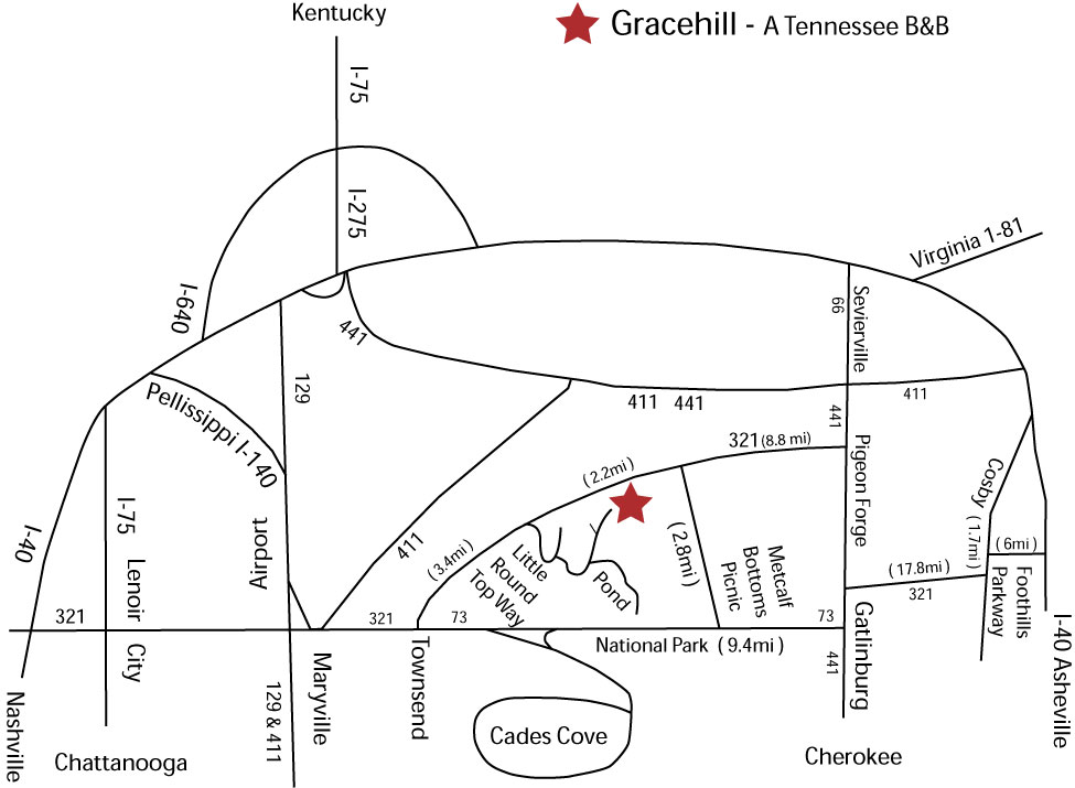
Exit 364 onto Hwy 321. Turn right at the top of the ramp and go a few miles; you will cross over I-75. Proceed another 39 miles through Lenoir City and Maryville/Alcoa into Townsend. At the only stop light in Townsend, by the Marathon station, Wears Valley Road/Hwy 321, turns left towards Wears Valley and Pigeon Forge. Turn left there and proceed 3.4 miles. Just past the riding stables on the left, you will see Little Round Top Rd. on the right. Turn right, proceed 4/10ths of a mile and turn left at the second left (you’ll see a Gracehill sign.) Proceed 3/10ths of a mile and the road turns into concrete. Come up the concrete another 3/10ths of a mile to the top.
From West Knoxville on I-40 EB:
Take the Pellissippi Parkway I-140 to Hwy 129 or on I-40 EB exit 376B onto Hwy 129 towards Maryville and McGhee Tyson Airport. Once past the airport, stay left and follow the signs into Maryville for Townsend, bearing left by Maryville College to stay on 321. Proceed about 15 miles into Townsend. At the only stop light in Townsend, by the Marathon station, Wears Valley Road/Hwy 321, turns left towards Wears Valley and Pigeon Forge. Turn left there and proceed 3.4 miles. Just past the riding stables on the left, you will see Little Round Top Rd. on the right. Turn right, proceed 4/10ths of a mile and turn left at the second left (you’ll see a Gracehill sign.) Proceed 3/10ths of a mile and the road turns into concrete. Come up the concrete another 3/10ths of a mile to the top.
From the Knoxville Airport:
Coming out of the Knoxville airport, McGee Tyson, stay to the right to get onto Hwy 129 South. As soon as you merge into traffic, get in the left hand lane and stay to the left when the road splits one mile ahead. You will be on Hall Road, then Washington St. for a few miles before it merges into Hwy 321 by Maryville College. You will immediately see the Hospital on your left, then a Food Lion grocery on your left. (If you need to purchase a bottle of liquor, the liquor store in that complex is your last chance! There is a new winery in Townsend called Cades Cove Cellars on the right as soon at your enter our little town.) Proceed about 15 miles into Townsend. At the only stop light in town, by the Marathon Station, Wears Valley Road/Hwy 321, turns left towards Wears Valley and Pigeon Forge. Turn left there and proceed 3.4 miles. Just past the riding stables on the left, you will see Little Round Top Rd. on the right. Turn right, proceed 4/10ths of a mile and turn left at the second left (you’ll see a Gracehill sign.) Proceed 3/10ths of a mile and the road turns into concrete. Come up the concrete another 3/10ths of a mile to the top.
From North Knoxville (or Cincinnati, OH; or KY) I-75 SB:
I-75 turns into I-275 SB. Ignore any signs that say take the I-640 bypass to Nashville, it can be a little confusing, just get on I-275 for a few miles to I-40 WB Nashville. You will only be on I-40 for less than a mile when you exit at 386B onto Hwy 129 towards Maryville and McGhee Tyson Airport. One mile past the airport stay left and follow the signs into Maryville for Townsend, bearing left at Maryville Collete to stay on 321. Proceed about 15 miles into Townsend. At the only stop light in Townsend, by the Marathon station, Wears Valley Road/Hwy 321, turns left towards Wears Valley and Pigeon Forge. Turn left there and proceed 3.4 miles. Just past the riding stables on the left, you will see Little Round Top Rd. on the right. Turn right, proceed 4/10ths of a mile and turn left at the second left (you’ll see a Gracehill sign.) Proceed 3/10ths of a mile and the road turns into concrete. Come up the concrete another 3/10ths of a mile to the top.
From Chattanooga on I-75 NB:
Exit 81 on Hwy 321, turn right at the top of the ramp. Proceed 39 miles through Lenoir City and Maryville/Alcoa into Townsend. At the only stop light in town by the Marathon station, Wears Valley Road/Hwy 321, turns left towards Wears Valley and Pigeon Forge. Turn left there and proceed 3.4 miles. Just past the riding stables on the left, you will see Little Round Top Rd. on the right. Turn right, proceed 4/10ths of a mile and turn left at the second left (you’ll see a Gracehill sign.) Proceed 3/10ths of a mile and the road turns into concrete. Come up the concrete another 3/10ths of a mile to the top.
From Bristol TN, VA, and points NE of here on I-81 SB:
I-81 SB merges into I-40 WB. Take Exit 407 for Rt. 66, turn left at the top of the ramp. Proceed 8.1 miles into Sevierville, cross over Hwy 411 and the road you are on turns into Hwy 441. Stay on Hwy 441 4.4 miles into Pigeon Forge. At stop light 3 turn right towards Wears Valley and Townsend. Proceed 11 miles, and immediately after crossing over the county line from Sevier County to Blount County on your left, turn into Little Round Top Rd. Proceed 4/10ths of a mile and turn left at the second left (you’ll see a Gracehill sign.) Proceed 3/10ths of a mile and the road turns into concrete. Come up the concrete another 3/10ths of a mile to the top. Those of you coming in from this direction, please check with the innkeeper on her take of the traffic situation. Sometimes it pays to go past exit 407 and proceed into Knoxville and approach Townsend from the Maryville side if Pigeon Forge is having a special events weekend or it is a holiday.
From Asheville, NC:
There are several ways you could approach. You could come through Cherokee and up over the mountain on 441 to Hwy 73 for a beautiful scenic drive. (Look for the sign that has you turn left towards Cades Cove and Townsend, that is 73. Once you make that turn Park Headquarters is immediately on your right.) see 2 paragraphs down for rest of directions….
Or you take I-40 WB to exit 407 in Sevierville, but traffic can be heavy once you get off the expressway. My favorite is a combination of a little scenery and less traffic (except the 3 miles coming through Gatlinburg) and it’s usually the fastest.
Take I-40WB to the Foothills Parkway exit. Get off at that exit and take it for about 6 miles. It empties out onto Hwy 321 in Cosby. Turn left and go 1.7 miles when 321 turns right towards Gatlinburg, turn there and proceed another 17.8 miles 321 hits the main drag in Gatlinburg, a “T” intersection. You want to take a left on Hwy 441 going towards Cherokee. You will have about 3 miles of traffic until just past stop light number 10 you enter the National Park. Ignore the signs that ask you if want to go to Pigeon Forge. After a couple of miles in the park you turn right onto Hwy 73 towards Cades Cove, the Visitor Center, and Townsend. It is very easy to miss this turn. Once you make the turn you will see on your right Sugarlands Visitor Center. (If you do miss the turn you will be headed towards Cherokee 33 miles away on the other side of the BIG mountain.)
….. So once you make the turn, and you see the Visitor Center on the right, Clock off 9.4 miles then turn right into Metacalf Bottoms Picnic area. Cross over the river, and proceed 2.8 miles. You will hit a “T” intersection, Hwy 321 again, turn left and proceed 2.2 miles. As you cross over the county line from Sevier County to Blount County, on your left turn into Little Round Top Rd. Proceed 4/10ths of a mile and turn left at the second left. Proceed 3/10ths of a mile and the road turns into concrete. Come up the concrete another 3/10ths of a mile to the top.